Image by S.C. Emergency Management DepartmentImage by 20090424-fire.jpg The fire has stayed west of S.C. 31. The Sun News has an excellent photo gallery of the damage (and a second), as well as another one of aerials.
Update April 26: The fire is nearing containment. Go read the latest.
Update April 24, late afternoon: One family is being singled out as the source of the blaze.
Update April 24: Fears are growing that the fire is going to turn north and threaten a community of homes. Read about it at The Sun News.
Here's a map of the burning and burned area as of 9:30 this morning. The most active area is to the right, and fears are high that section "C" could push north into the Poplar community.
First reporting:
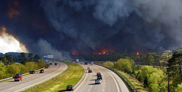
The wind-fueled fire continued its easterly march across the Myrtle Beach area on Thursday, and is expected to continue to do so today.
The latest from Twitter
(live updates)
If you're looking to dive straight in for more info, right now the front page of The Myrtle Beach Sun offers a plethora of fire coverage and is your best bet.
Read more stories on this subject in our Myrtle Beach fire topic page.But for those of you looking for something more succinct, keep reading.
Winds are expected to continue to blow the fire's march eastward on a path that has already burned some 20,000 acres, damaged 100 homes, and destroyed 69 more.
In all, 560 fire personnel are currently fighting the flames that are 40% contained and are focusing on the left side of the fire to protect homes (map below) -- currently Charleston County has one engine and four personnel fighting the flames, Colleton County has two engines and eight people there. In all the state's counties have contributed nearly two dozen engines and some 150 people to help in the fight.
The S.C. Emergency Management Department has released a debriefing at 7 a.m. Friday morning that has great detail on the status of the fire.
While tourists remain largely unfazed, the fire is still having a heavy impact on area inland, particularly with many schools closed due to the thick haze. And, The Sun News does a good job highlight some more interesting tales of human resilience against the flames.

S.C. EMDThe burned and burning area is shaded in pink. The black arrow indicates wind direction.
Other worthwhile resources:
The Sun News has an excellent photo gallery of the damage (and a second), as well as another one of aerials.
This map does a good job of showing where the fire is, and what's been affected.
Here's a copy of The Sun News' front page from today.
The S.C. Emergency Management Division is an excellent spot to stay abreast on all the latest details.
This map shows how the fire moved from west to east.

