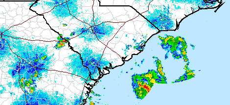
Image by National Weather ServiceImage by 20080718rain.jpg This 9:48 p.m. radar image shows the storm sitting off the coast. More intense colors indicate more moisture.
Update July 19: The system has formed into a tropical depression. Find out more.
If you've looked up today you've no doubt noticed the clouds around, well it looks like they'll stick around a bit, but the bulk of the rain may stay offshore.

Storm clouds were already brewing early Thursday evening.The National Weather Service says that it looks like the system will meander off the southern South Carolina coast, possibly dropping large amounts of rain.
But the agency still gives the system a "high" chance of forming into a cyclone during the next 48 hours.
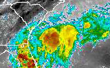
An infrared image showing the colder, moisture-rich ball of nastiness off our coast.High tides this weekend will be around 8 a.m. and 9 p.m., so watch for flooding then (when the tide is high it's harder for water to drain to the marshes).
For you data junkies out there, you can also get a data-rich graphical forecast of the weather. And read up on the forecast discussion to get the latest.

