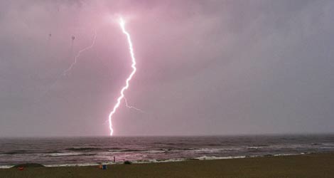
Image by flickr user ShuzuluzaImage by 20080623lightning.jpg More storms are likely this evening, so you may want to skip that late afternoon trek to the beach.
More intense rain, thunderstorms, and hail is expected along the coast this evening and tonight, mainly from 1 to 8 p.m. Winds may also exceed 60 mph.
From the National Weather Service's weather outlook:
Severe thunderstorms...an upper level disturbance interacting with an unstable atmosphere...the sea breeze...a cold front and leftover boundaries from yesterdays thunderstorms will result in scattered showers and thunderstorms this afternoon and evening. some of the storms may become severe...especially in southeastern south carolina. the main hazards from thunderstorms will be damaging winds in excess of 60 mph...hail possibly in excess of quarter size...deadly lightning...and heavy rainfall. severe thunderstorms are most likely from 1 pm until 8 pm.
NBC News 2's weather man offers a narrative on why we've been getting these storms:
Right now we have a persistent southeast flow at the surface which is pumping in tons of tropical air from the Caribbean. This is our moisture source. The next thing you have to have to cause thunderstorms is some kind of lifting mechanism. Most of the time in the summer, we rely on hot afternoon temperatures allowing the air to rise which will eventually cause a thunderstorm. However in this pattern, that is not the case. We are relying on boundaries such as the sea breeze circulation and little ripples of energy in the atmosphere called “shortwaves.” With all of the moisture in the air and weak shortwaves constantly passing over head, storms are popping up at weird times of the day and not following that typical afternoon and evening pattern.
Bookmark this page and visit the National Weather Service to stay updated. Also, view their radar map.

