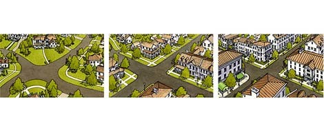
Image by SmartCodeImage by 20081021smartcode.jpg Another rural plan based off the SmartCode.
The City of Charleston's vision for Johns Island was shared with the community of Monday night, and compared with how controversial most meetings about development are on the island, it was an almost warm greeting of the plan.
Read more stories on this subject in our Johns Island topic page.The Johns Island SmartCode is an attempt to allow the island to be developed, yet largely maintain the current rural feeling. As the city puts it: "The key point is to create a code that will protect what is treasured while continuing to allow the island to grow."
Most of the island would keep zoning rules that encourage smaller more sparse developments, while three areas would be allowed to develop into "towns." Those towns would be the 21st century swap for strip malls, possibly having buildings up to five-feet tall.
There would be three such gathering places, all on Maybank Road.
Behind the overall principle of the plan is the "SmartCode," which the project describes as: the SmartCode keeps towns compact and rural lands open, while reforming the destructive sprawl-producing patterns of separated use zoning.
But, such aspirations virtually require that the city's vision of a network of smaller roads for Johns Island prevails over more standard five-lane road.
Hop over to the city's Web site for more on the project, and The Post and Courier for more on the night's meeting.