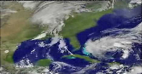
Image by NOAA/NASAImage by 20080904hannahvid.jpg Hanna's clouds are approaching, its rain and winds aren't far away. On the left is Gustav breaking down, and on the right is Hanna wobbling away. The video shows the storms from Saturday to about 9 a.m. today.
Update 6 p.m.: The latest forecast from the National Hurricane Center indicates that Hanna may not regain hurricane strength. Because of weather in the southeast, the storm has had trouble organizing into a strong system.
But, remember, there's little difference between a strong tropical storm and minimal hurricane.
Original post: The latest forecasts show Hanna largely missing Charleston, but we're still sure to get some rain and wind out of it.
There's even talk about how the storm is having a hard time organizing itself into a more powerful hurricane. So, things are looking better, but still stay alert. Charleston County government isn't ignoring Hanna either, as they stepped up their readiness-level today.
But, by Wednesday or so of next week, Ike could be rolling into the Bahamas and possibly our way. But it's far too early to know for sure, but it does look like Ike will be far more powerful than Hanma. Here's the 5-day forecast.
Stay alert for Hanna, as the storm's path can always change.