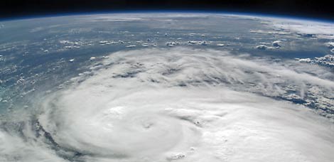
Image by NASAImage by 20080820faypicture.jpg Fay is big, spread out, and full of wet stuff.
Update August 22: We've updated our Fay coverage. Go read it.
Update 9:12 a.m.: We checked in this morning and more rain is still expected, gradually increasing through the morning as Fay's outer reaches wash over us.
Be particularly cautious around 11 a.m., when flooding is more likely as it is high tide.
Lightning, flooding, tornadoes, heavy rain, high surf, rip tides are all in the warnings today.
Go and view The Weather Channel's animated weather map and the National Weather Service's full forecast.
FYI, Fay's eye is set firmly on Florida.
We'll keep you posted.
Original post: Though we've dodged Fay's most intense harassment, the storm's reach is harassing us with rain and some wind gusts, and likely will for the next couple of days.
Read more stories on this subject in our Fay topic page.The National Weather Service had this to say about conditions in Charleston:
Winds are currently averaging 15 to 25 mph with gusts near 30 mph across much of south coastal South Carolina late this afternoon. Winds will continue to slowly increase tonight into Thursday...but sustained tropical storm force winds are not expected at this time. However gusts in excess of 40 mph could occur in passing squalls.
Wind gusts in excess of 40 mph could break small tree branches and limbs...which could fall on power lines. Saturated soils from heavy rains experienced over the past few weeks may also increase the risk for downed small trees and power lines.
Some useful links:
- Weather map
- View a map of rainfall in the last hour
- Report a power outage: 1-888-333-4465 (streetlights and outdoor lighting: 1-800-251-7234)
- SCE&G's mobile Web page
- SCE&G's storm tips
- Area traffic cameras
While the official forecast still shows the eye of fay sticking to the Florid coast, high surf of 4 to 7 feet is expected. (And, we know how effective that is at keeping surfers away. But, really, you should be careful). Check out the Folly Beach surf cams. NBC News 2 reports that surfers are, in fact, rather enjoying the waves.
The intensity of rain and thunder is expected to increase over the next 24 hours. There's also a risk of tornados.
The greatest risk of flooding comes during high tide, which is around 11 a.m. and 11 p.m. the next couple of days.
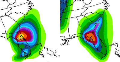
NOAA
Forecast rainfall for Thursday (left) and Friday. More intense colors indicate more expected rainfall.


