7:06 am on Saturday March 14, 2009
| Posted by Ken Hawkins
Charleston harbor being mapped for Civil War relics
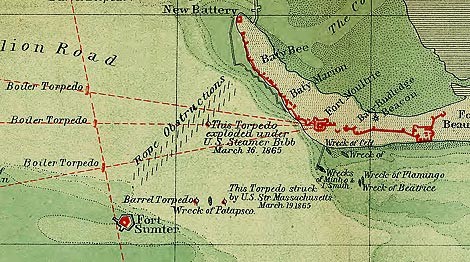
Image by Library of CongressImage by 20090314-map.jpg The edited caption: General map of Charleston Harbor showing rebel defenses and obstructions. Prepared by direction of Rear Admiral J.A. Dahlgren U.S.N. commanding South Atlantic Blockading Squadron by C.O. Boutelle Asst. U.S. Coast Survey. Download the full map.
A $28,000 federal grant is being put to use to map Charleston's harbor for the remnants of ships, underwater defenses, torpedoes, and more used during the Civil War.
Read more stories on this subject in our history topic page. Head over to The Post and Courier for the story about what they're doing and what they're hoping to find.
The paper talks about a detailed map, here it is at the Library of Congress and here's an easy-to-view full resolution version.

